Helicopter Spur, the gentle bastard of a climb.
Mid December 2019
The plan.....
- Start at Upper Howqua camp ground
- Head up Helicopter Spur
- Night 1 - Camp at King Billy
- Traverse the AAWT across Mt Magdala
- Head across Mt Howitt
- Head down Stanley Named Spur (aka SNS)
- Night 2 - Camp near the water source on SNS
- Head down SNS and then down Queens Spur Track to the Upper Howqua camp ground
- All up, 26km over 3 days.
 |
| The whole walk. All 3 days. |
Ah, yes, it looked so good on the map, then in the pub, as we mulled over a beer. The Bonnie Doon pub, a beaut eating place as we headed up to Mansfield, then Upper Howqua camping ground for the night.
Day 1 - Upper Howqua camp ground to King Billy - 6.46km Hard walking and rock scrambling.
 |
| Day 1 |
The next morning, a lucky Friday 13th, would see us up and moving just after 9am. A few other campers had arrived at the camp ground, but a quiet start to a 3 day hike.
The first 2kms we knew well, as we had assisted Bushwalking Victoria with a track clearing weekend in late November, 2019. A moderate climb along an old logging track saw us reach the left turn towards the spur in 40min. At this point, we noticed the Bird Orchid in flower. It was right next to the track, and easy to accidentally step on.
The track now headed east, as we started to climb through open scrub. The track was easy to find, as we simply had to keep to the top of the spur. A few fallen trees slowed our climb as we headed for our first challenge, the first of 3 rocky cliffs.
 |
| Early part of the spur track. Easy going. |
 |
| Track markers came in all shapes, sizes and types! |
 |
| The track became a little steeper and more defined along the ridge. |
Approaching the first rocky band, we come from the right, then the track headed to the left. Following an easy foot pad below the cliff, we found an easy route up the cliff.
 |
| The first rocky band. The track (to the right), swings left under the cliff line. |
 |
| The first rocky band. |
|
The first rocky band wasn't too hard (from memory). The second was a little more involved (see the following videos). While we didn't need ropes going up, I suspect you would need them coming down. Or, just throw the packs down, as some folk were doing! Not a favorite idea of mine.
In the end, brute force and no ropes were required to climb the cliff.
As a distraction, the amount of wild flowers out in bloom was amazing.
 |
| March fly on Alpine Everlasting. |
The track is fairly clear and easy to follow.
 |
| Approaching rock band 2. |
 |
| Rock band 2 |
 |
| At the top of rocky band 2, a beaut, exposed rock outcrop. |
Rock band 3 was fairly easy.
 |
| Rocky band 3, a fairly easy, short scramble. |
Finally, at the top of the climb, we had this gentle rolling slope. A beaut view looking back to the valley.
 |
| At the top of the climb. |
Yes, a little weary, but we made it up the spur! Would do it again...one day..... :)
 |
| Made it! |
Once off the climb, the track made its way to a dirt road, which passed
Picture Point, then merged with Bluff Track. Easy walking.
 |
| Carolyn on the road. |
 |
| Skink sunning itself. |
The first nights camp site had been mentioned to me by a Parks Ranger.
It was about 250m off the main track, heading east. A beaut flat, green
area to pitch a tent. But the issue with lots of black ant nests kept us
searching (stamp your foot on the ground....if ants appear in 10
seconds, try else where). Water was found about 200m to the NE, where a small creek flowed. It wasn't fast flowing but enough to fill up and cook with. A peaceful location. The rest of the crowd (around 5-6 4WD) had camped back near the road.
 |
| First nights camp site. |
Day 2 - King Billy to Stanley Named Spur (via Mt Magdala) - 10.38km Easy walking, up and down.
 |
| Day 2 |
The walk from King Billy to Mt Magdala is a little up and down. Not a
lot, but enough to raise a sweat. But the views are stunning as we
follow the top of the cliff line. While Mac Springs is nearby, there were very few folks around. The biggest group we saw were a deer hunting group made up of 5-6 people. Wasn't really comfortable with people shooting around these parts. But I suspect, the number of rangers to manage this sort of thing are very low.
 |
| Heading up to Mt Magdala. A climb that's worth it in the end. |
The view from the top, Mt Magdala. Mt Howitt is just to the right of center, Howitt West is to the left (in the center), with the Cross Cut to the left.
 |
| Carolyn takes a breather at the top of Mt Magdala. |
 |
| Hells Window, as we descend Mt Magdala. Mt Buller in the distance. |
We stopped for lunch at the camp site below Mt Magdala, near the path that leads to Hell fire creek. A great camp site, on a saddle, dotted with large old snow gums. The track to Hellfire Creek is about 400+m. Initially, as you head down the track, you wonder where the creek could be. It seems way off. But as you traverse around the slope, its there, with that beaut, water trickling sound :)
 |
| Hell fire creek. A lovely spot to collect water. |
Ah, the Viking. Been there and done that. A super challenging climb. Will do it again, next year, as part of our AAWT walk.
 |
| From Mt Howitt, the view looking towards the Viking. |
|
 |
| The Cross Cut Saw, with Mt Speculation to the middle right. |
|
The start of the descent down the Stanley Named Spur. It intersects with the Cross Cut Saw track. The first km down to the camp site is a little rocky and challenging, but worth it. Initially, the decent starts off well, the track is clear, but soon it becomes an undefined scramble. The approach is to simply follow the ridge line and the odd rock cairn. Plus the scramble marks.
 |
| The start of the Stanley Named Spur descent. |
Day 2 campsite was on the small plateau about 1km down from the start of the descent. 100+m away was a beautiful flowing stream, the headwaters of the King River. Not a lot of choice for a tent site, but we arrived at around 3'ish and had the place to ourselves. A couple of hours later, a group of young guys arrived, from the Upper Howqua camping area. A bit of a long slog IMO (up Queens Spur Track, then the Stanley Named Spur). We were heading in the other direction, tomorrow.
 |
| Camp site and Carolyn, after the rocky descent of the upper Stanley Named Spur, Mt Howitt in the background. |
Day 3 - Stanley Named Spur back to the car (at Upper Howqua camp ground) - 9.38km Easy walking, mostly downhill.
 |
| Day 3 |
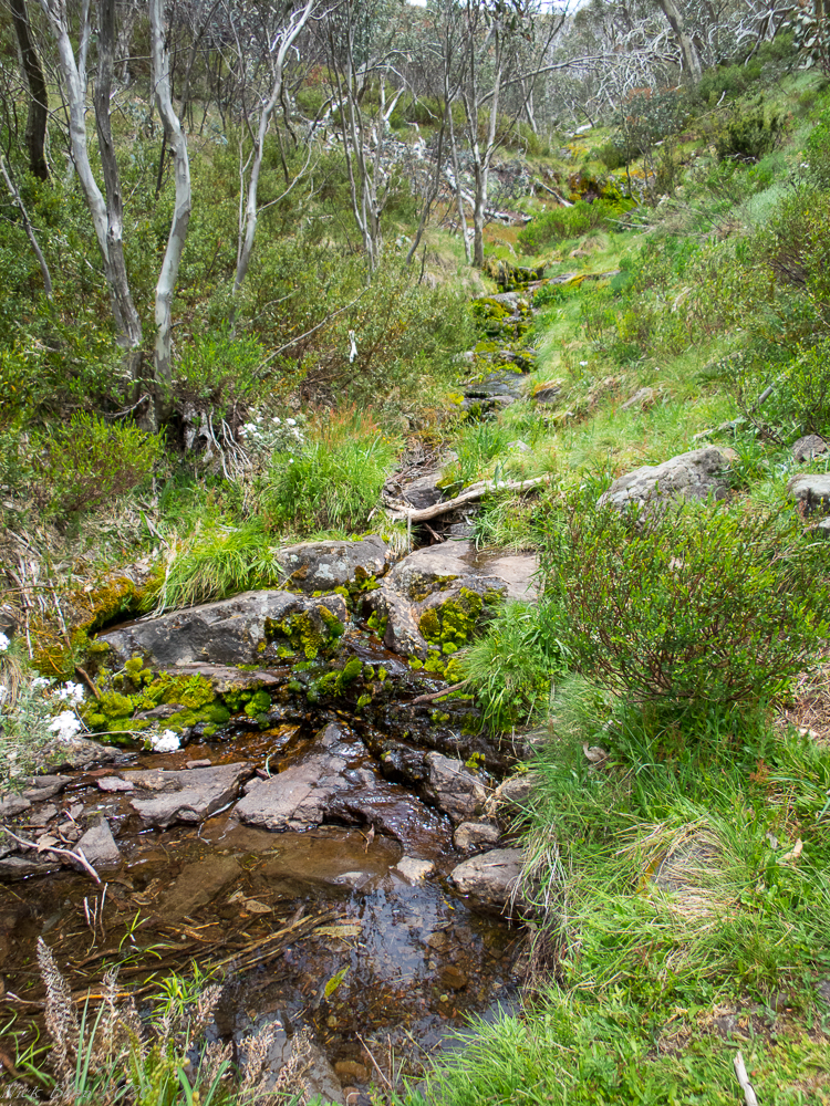
The weather was perfect. Having breakfast and packing up, we were walking by 8:30am. Glad we stopped here as its been on my list to check out for a number of years. The water source, the views, just great.
 |
| The creek near Stanley Named Spur track |
 |
| Bulbine lily, there were masses of them in the Alpine areas. |
 |
| Stanley Named Spur Track, a few fallen trees to deal with. |
The only "tricky" navigation bit is the last km before the intersection of Stanley Named Spur track and Queens Spur track. The SNS track heads around an outcrop of red rocks, then heads due west, through some knee/waist high growth, then through a wall of under story. The under story can be a little difficult as deer have made tracks through this section, which is a little misleading. Fortunately, some pink flagging tape marks the entrance. Our first attempt a few years back didn't have this tape and it took a few goes to work out where the start was. Once through this section, probably 0.5km, it opens up to a grassy meadow. Head down this grassy section to a saddle, where the Queens Spur track appears to the left (the well trampled foot pad is the giveaway).
 |
| Stanley Named Spur Track heading to Queens Spur Track. Just turn left. |
An old fire bunker exists at the intersection of Queens Spur track.
 |
| Old fire bunker, near the intersection of Queens Spur Track and Stanley Named Spur. |
Blackberries are becoming an issue on a couple of spots along the Queens Spur Track. Some serious work will be required over the coming years.
 |
| Queens Spur Track, a little over grown with blackberry. |
On the lower sections of Queens Spur Track, the native fernery display is magic. Such a lush green environment.
 |
| Tree ferns in the lower section of Queens Spur Track. |
 |
| Lower reaches of the Queens Spur Track, as it merges with the Howqua River. |
On many other walks we have done here, we would head up Howitt Spur, then back down Stanley Named Spur / Queens Spur. So it was a great adventure, doing Helicopter Spur, that gentle bastard of a climb.
 |
| The junction, Queens Spur track (left) and Howitt Spur Track (right) |
|


No comments:
Post a Comment